


Table of Contents
Satellite Observation of Deep Depression over Southwest Bay of Bengal
The Bay of Bengal, located in the northeastern part of the Indian Ocean, is a critical region for tropical cyclones, storms, and depressions, making satellite observations of such systems essential for monitoring, forecasting, and disaster management. The deep depression is one of the earlier stages of tropical cyclones and can sometimes evolve into more severe weather systems, like cyclones. This article delves into the importance and role of satellite observation in tracking and studying deep depressions, specifically those occurring over the Southwest Bay of Bengal.
Understanding Deep Depression
A deep depression is a well-defined low-pressure area, characterized by sustained winds of 34-47 knots (63-87 km/h), with organized cloud systems and atmospheric convection. It is the stage before a tropical cyclone intensifies into a cyclonic storm. Over the Bay of Bengal, the deep depression can develop into a cyclone, which poses significant risks to coastal regions in India, Bangladesh, and Myanmar, along with their respective fishing industries, agriculture, and infrastructure.
Importance of Satellite Observation
Satellite technology is indispensable in modern meteorology, especially for monitoring and predicting the behavior of weather systems over vast and often inaccessible regions like the Bay of Bengal. With the capability to capture real-time data over both land and oceans, satellites provide comprehensive coverage of storm development, evolution, and movement, which is critical for:
- Early warning systems: Satellites help to provide timely alerts to authorities and populations at risk.
- Tracking storm systems: Observation of the depression’s location, intensity, and structure is essential for accurate predictions of its movement and landfall.
- Environmental monitoring: Understanding the surrounding atmospheric and oceanic conditions such as sea surface temperatures, wind patterns, and moisture content.
Key Satellite Systems Involved
Several satellite platforms, both geostationary and polar-orbiting, are utilized for real-time observations and data collection of tropical weather systems. These include:
- Geostationary Satellites: Positioned at fixed points above the Earth, these satellites continuously monitor weather systems over specific regions. They offer a high-frequency view of cloud formations, precipitation patterns, and the development of low-pressure areas. The INSAT series operated by India (Indian National Satellite System) is one of the primary geostationary satellites used for monitoring the Bay of Bengal.
- Polar-Orbiting Satellites: These satellites, such as those from the NOAA (National Oceanic and Atmospheric Administration) and NASA in the United States, offer a global perspective. They orbit the Earth from pole to pole, passing over the Bay of Bengal at different times, which allows them to capture atmospheric conditions from various angles and altitudes. They also gather data on sea surface temperatures and atmospheric profiles, crucial for cyclone prediction.
- SAR (Synthetic Aperture Radar) Satellites: These satellites provide information on ocean surface winds, helping to track storm intensity. Radar systems, such as RADARSAT and ESA’s Sentinel-1, offer valuable insights, particularly in detecting surface winds and atmospheric moisture, which play an important role in assessing the potential for cyclogenesis (the development of cyclones).
- Scatterometer Satellites: These instruments measure wind speeds over the ocean’s surface, providing essential data to assess the storm’s intensity. The QuikSCAT and ASCAT instruments onboard the European and NASA satellites are key tools for monitoring winds in the Bay of Bengal.
- Advanced Weather Satellites: Instruments such as the Meteosat series and the Himawari-8 satellite from Japan offer advanced tools for atmospheric observation, cloud formation, temperature distribution, and wind patterns. These satellites contribute valuable information to the models used to forecast storm developments over the Bay of Bengal.
Satellite Data for Tracking a Deep Depression
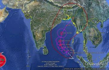
When a deep depression forms in the Southwest Bay of Bengal, satellites become an essential tool for tracking its path and development. The data provided by these satellites is used by meteorological agencies to predict the storm’s movement and intensity, guiding both preemptive evacuations and other precautionary measures.

- Cloud Formation and Infrared Imaging: The cloud structure and convection patterns around a deep depression can be tracked using infrared imagery from geostationary satellites. By observing cloud top temperatures and the organization of cloud bands, meteorologists can gauge the strength and likelihood of intensification. For example, a well-organized convection pattern and deepening cloud tops often indicate that the depression may intensify into a tropical storm or cyclone.
- Sea Surface Temperature (SST) Monitoring: A deep depression often forms over warm ocean waters, where SSTs are typically 26.5°C or higher. Polar orbiting satellites provide critical data on SSTs in the Bay of Bengal, which helps to predict whether the system will strengthen. Elevated SSTs feed energy into the depression, encouraging further development.
- Wind and Pressure Analysis: Satellites also provide key information on wind speeds and atmospheric pressure patterns. In particular, scatterometer and SAR satellite data can identify wind speed changes over the ocean, which is essential for determining the intensity of a depression. A steady increase in wind speed and a decrease in atmospheric pressure often signal an intensification into a cyclonic storm.
- Atmospheric Moisture and Humidity: A deep depression relies on significant moisture content for development. Satellites can monitor the water vapor in the atmosphere through infrared imagery and other remote sensing tools. These measurements help identify the areas of convergence and divergence that lead to storm strengthening or weakening.
Satellite Data for Forecasting
Once the deep depression is detected and its initial parameters are determined, satellite data contributes to numerical weather prediction (NWP) models, which simulate the storm’s behavior based on its current state and environmental conditions. These models use satellite data on wind, pressure, temperature, and humidity to predict the future trajectory, intensity, and landfall of the depression.
- Track Prediction: Using data from geostationary satellites, meteorologists track the motion of the depression and determine its possible movement across the Bay of Bengal and towards the Indian subcontinent. This helps to identify regions at risk of direct impact, including coastal states like Andhra Pradesh, Odisha, Tamil Nadu, and West Bengal.
- Intensity Forecasting: The data from satellites, when integrated with historical cyclone data, helps predict whether the deep depression will intensify into a cyclone, or whether it will dissipate. Satellite observations of cloud tops, wind patterns, and sea surface temperatures are vital in making these predictions.
Role in Disaster Preparedness
Satellite data plays an integral role in disaster management. Accurate tracking and forecasting of deep depressions and their possible intensification into cyclones are crucial for timely warnings. Early warnings based on satellite observations allow local authorities and agencies to:
- Issue advisories: Ensuring that communities in the potential path of the depression receive timely evacuation warnings, along with the necessary resources to prepare.
- Coordinate evacuations: Knowing the likely landfall areas allows authorities to organize evacuation plans and direct resources to vulnerable areas.
- Minimize losses: By tracking the storm’s development early, governments can reduce infrastructure damage, loss of life, and disruption of essential services.
Conclusion
The observation of deep depressions over the Southwest Bay of Bengal using satellite technology is critical for early warning systems and effective disaster management. With advancements in satellite imagery, data collection, and modeling, meteorologists can now predict the formation, movement, and intensity of tropical depressions with greater accuracy. This has proven invaluable in saving lives, protecting property, and enabling timely evacuations. As technology continues to evolve, satellite observation will remain at the forefront of monitoring and managing weather systems in the Bay of Bengal.


