


Table of Contents
Eye on the Storm: How ISRO’s Satellites Are Tracking Every Move of Cyclone Fengal
Cyclones are some of the most destructive weather phenomena, often causing extensive damage to coastal regions and disrupting lives. The Indian Space Research Organisation (ISRO) plays a crucial role in tracking and monitoring cyclones that form over the Indian Ocean, including the Bay of Bengal and the Arabian Sea. These areas are particularly prone to tropical storms, which can intensify into cyclones that threaten lives, property, and infrastructure. Cyclone Fengal, a recent storm in this region, has been closely monitored by ISRO’s advanced satellite systems, helping meteorologists and authorities track its every move in real-time. This article explores how ISRO’s satellite technology is integral to monitoring Cyclone Fengal and ensuring timely and accurate forecasting to safeguard affected populations.
The Role of ISRO in Cyclone Monitoring
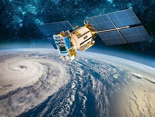
ISRO’s satellite technology has revolutionized weather forecasting and disaster management in India. India’s vast coastline and proximity to tropical storm-prone areas necessitate an efficient and reliable system for tracking cyclones, forecasting their trajectory, and issuing timely warnings. Through a combination of geostationary satellites and polar-orbiting satellites, ISRO provides critical data for real-time monitoring of cyclonic systems like Cyclone Fengal.
ISRO’s Indian National Satellite System (INSAT) and Indian Remote Sensing Satellites (IRS) are central to this mission. These satellites capture high-resolution imagery, atmospheric data, and other key indicators essential for tracking the formation, intensification, and movement of cyclones. By analyzing this data, ISRO can assist meteorological agencies like the India Meteorological Department (IMD) in issuing early warnings, optimizing evacuation plans, and enabling better disaster preparedness.
Cyclone Fengal: A Brief Overview
Cyclone Fengal is a recent storm that formed in the Bay of Bengal, a region known for producing powerful tropical cyclones. Like many such systems, Fengal started as a low-pressure area before intensifying into a deep depression. Over the course of several days, it strengthened and became a full-fledged tropical cyclone, with wind speeds reaching sustained speeds of over 100 km/h. The storm posed a significant threat to coastal states in eastern India, particularly Odisha and West Bengal, with the potential for widespread destruction due to high winds, heavy rainfall, and storm surges.
Satellite Technology Used to Track Cyclone Fengal
- INSAT Series: Continuous Monitoring with Geostationary Satellites
The INSAT series of geostationary satellites are some of ISRO’s most important tools for cyclone monitoring. These satellites orbit the Earth at a fixed point above the equator, allowing them to continuously monitor the same area. For tracking cyclones like Fengal, this is crucial because it provides frequent updates on the storm’s evolution. INSAT satellites carry out high-frequency imaging using Visible and Infrared (VIR) Radiometers, which capture cloud formation, temperature patterns, and the structure of the cyclone. These observations are vital for identifying the cyclone’s intensity, size, and central pressure.
INSAT’s Cloud Imaging and Lightning Detection (CILD) system also helps track the storm’s convective activity—areas of intense cloud formation that are indicative of the cyclone’s strength. By analyzing cloud top temperatures and convection patterns, ISRO can predict whether the storm is intensifying or weakening. This is especially important for determining whether a deep depression will escalate into a more dangerous cyclone.

- Cartosat-2 and Cartosat-3: High-Resolution Imagery
For precise monitoring of the cyclone’s impact, Cartosat-2 and Cartosat-3 satellites are also used by ISRO. These high-resolution satellites can capture detailed imagery of the storm’s cloud formations, wind speed patterns, and the surrounding environment. Cartosat-3, in particular, provides panchromatic images with a spatial resolution of up to 0.25 meters, making it highly useful for assessing the cyclone’s movement over coastal areas and identifying landfall locations.
These satellites also assist in tracking damage after the cyclone has passed through affected regions, providing valuable data for disaster response teams. The high-resolution imagery helps assess damage to infrastructure, vegetation, and coastal areas, allowing authorities to deploy resources quickly and efficiently.
- RISAT: Radar Imaging for Storm Monitoring
ISRO’s Radar Imaging Satellite (RISAT) provides another key layer of data in tracking cyclones like Fengal. RISAT-1 and RISAT-2, which use synthetic aperture radar (SAR), are particularly useful for capturing storm dynamics and monitoring surface winds and rainfall over the ocean. Unlike optical satellites, SAR satellites can provide data regardless of cloud cover or lighting conditions, making them crucial for cyclone monitoring during both day and night.
RISAT satellites are also used to observe sea surface roughness and wind patterns around the cyclone, providing real-time updates on the storm’s intensity. These measurements help estimate the potential for rapid intensification, a common characteristic of cyclones in the Bay of Bengal.
- Oceansat: Monitoring Sea Surface Conditions
Oceansat-2 and Oceansat-3, ISRO’s dedicated ocean observation satellites, provide critical data on sea surface temperature (SST), sea surface height, and ocean currents. These parameters are essential for understanding the storm’s interaction with the ocean and predicting its future development. Cyclones like Fengal draw energy from warm ocean waters, so by monitoring the SST, ISRO can predict the cyclone’s potential to intensify.
Oceansat’s Ocean Colour Monitor (OCM) also helps detect changes in oceanic conditions, such as turbulence or upwelling, which are often associated with cyclonic systems. This data, when combined with other satellite observations, can help meteorologists assess the cyclone’s long-term trajectory.
- Dawn of New Data: The Role of Global Satellites
While ISRO’s indigenous satellites play a vital role in monitoring Cyclone Fengal, the organization also collaborates with international space agencies. Satellites from NASA, NOAA, and the European Space Agency (ESA) provide complementary data that enhances the accuracy of forecasting. For example, NASA’s MODIS (Moderate Resolution Imaging Spectroradiometer) and GOES (Geostationary Operational Environmental Satellite) provide real-time data on the cyclone’s cloud formations and atmospheric properties, which helps track its development.
The data from these global satellites, combined with ISRO’s own assets, helps create a comprehensive picture of the storm’s behavior, allowing meteorologists to issue timely warnings and updates.
Data Integration and Forecasting
ISRO’s satellite data is integrated into advanced weather models used by agencies like the India Meteorological Department (IMD). These models combine satellite imagery with atmospheric, oceanic, and terrestrial data to predict the cyclone’s path, intensity, and potential impact on coastal regions. With access to real-time information from multiple satellite sources, the IMD can issue accurate forecasts about the cyclone’s movement and warn people in the affected areas well in advance.
The Impact of ISRO’s Monitoring Efforts
- Early Warning Systems: The real-time satellite observations of Cyclone Fengal allowed authorities to issue timely warnings to populations in the potential path of the cyclone. By using data from INSAT, RISAT, and other satellites, the IMD was able to predict the cyclone’s landfall and intensity, providing crucial time for evacuations and the preparation of emergency services.
- Disaster Management: Post-cyclone assessments using high-resolution satellite imagery enabled effective disaster response and recovery. The data allowed authorities to identify the worst-hit areas and deploy relief teams efficiently.
- Public Awareness: ISRO’s satellite data is also shared with the public through various platforms, helping communities prepare for the cyclone. This contributes to better public awareness and community engagement in disaster preparedness.
Conclusion
ISRO’s satellite systems have become indispensable tools for tracking and forecasting cyclones like Fengal. By providing real-time data on the cyclone’s formation, intensity, and movement, ISRO contributes to more accurate predictions and timely warnings, helping to minimize the impact of such storms on vulnerable coastal populations. The combination of advanced geostationary and polar-orbiting satellites, along with international collaborations, has made India’s cyclone monitoring system one of the most advanced in the world. As cyclone frequency and intensity are projected to increase due to climate change, ISRO’s role in disaster preparedness and response will continue to be pivotal in saving lives and protecting infrastructure.


